

Some brief notes on the similarities of the rock-types of Pool Farm cist-slab, Hautville’s Quoit, Somerset, and Sarsen Stones at Fyfield Down, Wiltshire.
On a recent visit to Bristol Museum to view an exhibition – The Cave Art of Lascaux: A Virtual Reality Experience, I took some time to examine the Pool Farm cist-slab on display in the “Curiosities” section.
In 1930 a round barrow was excavated at Pool Farm, West Harptree, Somerset (NGR ST 5375, 5417). At the centre of the barrow a stone cist was discovered. The cist was constructed from several slabs comprising Dolomitic Conglomerate, Carboniferous Limestone, Liassic Chert, and sandstone. In 1931, the barrow was removed, and the material used for road-widening, the cist was left in-situ (Grinsell, 1958). The ‘carvings’ on the Pool Farm cist slab were recognised in May 1956 when the slab was removed to the City of Bristol Museum where it still remains. A replica of the slab is on display at Wells and Mendip Museum.
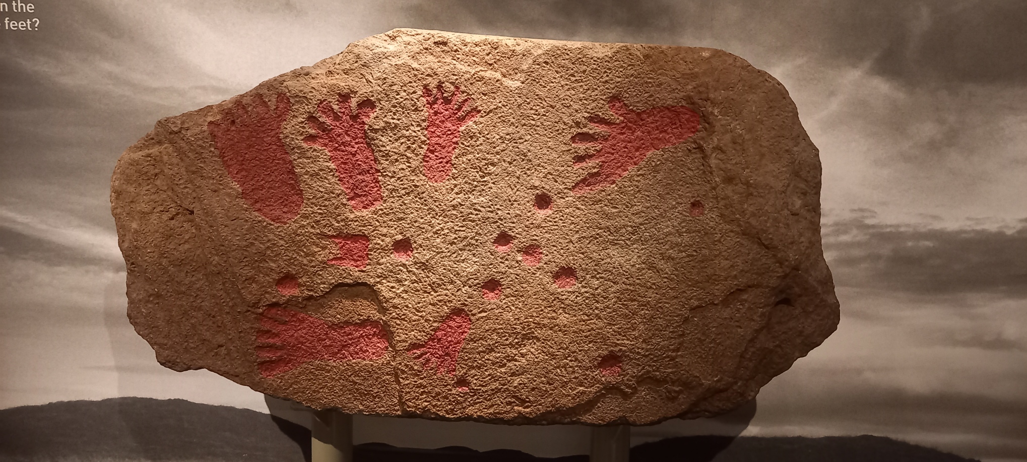
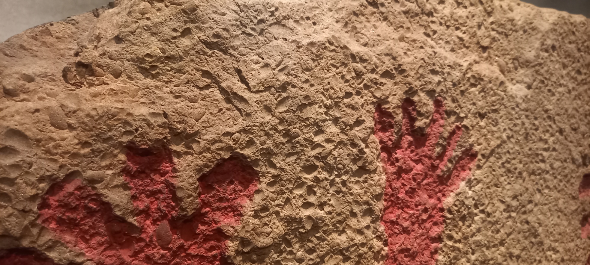
In Grinsell (1958) the cist slab rock type is described as “…a fine-grained pinkish sandstone containing numerous lamellibranchs”. Lamellibranchia (and Pelecypoda) are alternative names for Class Bivalvia, Phylum Mollusca. The bivalves are distinguished from other molluscs by their laterally compressed body enclosed between two bilaterally symmetrical, calcareous valves which are joined on the dorsal side by an elastic horny ligament. The bivalves are entirely aquatic, found in both marine and freshwater environments, the majority in shallow water. The fossil record of the Mollusca dates from the earliest Cambrian to Recent. Modern examples of bivalves include clams, cockles, mussels, and oysters (Black, 1988). A later description by Roger Clark, [then] Curator of Geology, at Bristol City Museum presented in Coles, et al (2000) reports “that the stone is almost certainly from the Harptree Beds, which consist of siliceous limestones and calcareous shelly limestones: these outcrop on the northern slope of the Mendip Plateau between East Harptree and Oakhill. The slab has abundant traces of decalcified bivalve molluscs, mostly corbulids and/or nuculids. The stone is local, perhaps coming from within a kilometre or so of the barrow”. Nucula is a Mesozoic bivalve living an a richly organic substrate from offshore to abyssal depths. Date ranging from Cretaceous to Recent (Black, 1988).
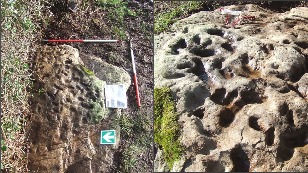
Personally, I do not agree with Clark’s assignment of the rock-type as originating from the local Harptree Beds. The rock-type of the cist-slab bears some remarkable similarities to that of Hautville’s Quoit at Stanton Drew, where a detailed archaeological investigation of the scheduled ancient monument (Monument No.BA44) was undertaken by the author and members of the Bath and Camerton Archaeological Society (BACAS) and a report was later published in 2012 in collaboration with Bath & North East Somerset Council.
Hautville’s Quoit is located at Quoit Farm, near Stanton Drew (NGR ST 60173, 63811). According to the BGS 1:50 000 Map (Sheet 264) the underlying geology comprises Mercia Mudstone strata of Triassic age, this in turn overlies, unconformably, strata of Supra – Pennant Measures which form part of the Upper Coal Measures of Carboniferous age, below at an unspecified depth.
To the east and south of the site is alluvium of Pleistocene and Recent age; also, to the east of the site and below at unspecified depth is the Pensford No.2 Coal Seam. The soils found at Quoit Farm are likely to be derived from the erosion and subsequent transport of material from the Lias strata of Jurassic age that forms the high ground to the north of the site. In particular, from a layer consisting of mainly clay and shale, there is a substantial area of landslip on the slopes of Maes Knoll (East Dundry) and around the village of Norton Malreward. The strata that comprise the landslip are described as mainly clay with White and Blue Lias, mainly limestone, also of Jurassic age. The clay content of these soils is likely to retain a higher moisture content than the sandy soils of the stone circle site on the south side of the River Chew.
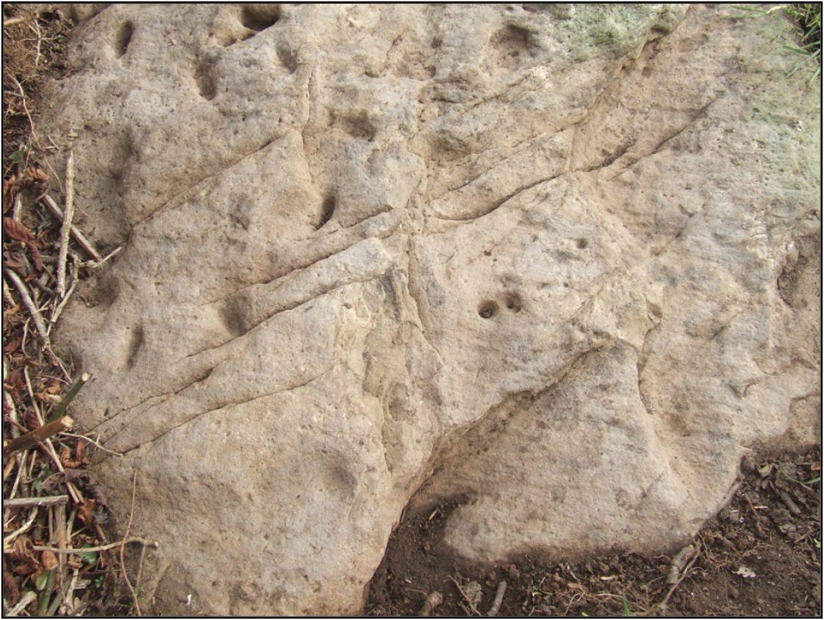
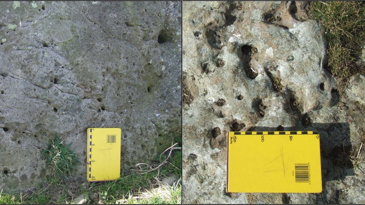
Hautville’s Quoit consists of a pale brown to grey sandstone. The sandstone can be described as comprising subrounded to rounded (high sphericity), fine to medium (250 – 375 microns), well to medium sorted, shiny, polished, mostly translucent grains of quartz, that appear matrix supported in a siliceous cement. There are noted numerous small clam-like (bivalve) fossil shells measuring up to 10mm x 6mm in an area of exposed bedding surfaces, these fossils are possibly a marker bed and might be useful in determining the origin of the rock type; these fossils have not yet been identified. A white scaly appearance on some parts of the stone was likely due to lichen growth or as a result of weathering. The pock-marked surface might be the consequence of a number of factors, including the effect of roots or solution. There are a number of lines of cleavage and other surface features visible on the stone. With regard to the Pool Farm cist-slab, Coles et al (2000) observe that “The whole surface of the slab appears to have been ground down to make some sort of uniform canvas for carving…”
Discussion and follow-up fieldwork:
On a purely personal note, the rock type that comprises Hautville’s Quoit is not one that is recognised either locally, or in the broader surrounding area. There are a number of features of the stone that require further consideration. Some subsequent fieldwork in the Mendip area has been carried out in the Ebbor Gorge area to look at exposures of the Quartzitic Sandstone Group (QSG) associated with the Ebbor Thrust. However, it is thought unlikely that this particular exposure provided the source for Hautville’s Quoit.
Lloyd-Morgan (1887) described the rock type that comprises the quoit as fine-grained sandstone. Lloyd-Morgan hesitates to offer any opinion as to the source of sandstones found at Stanton Drew, either that of the quoit or the stones found in the stone circle close by and states, “of the source, geological and local I am doubtful”, he does, however go on to ask the question “Is it possible that one or more of the sandstone monoliths may be sarsen – but whence?”
Roger Mercer, Inspector of Ancient Monuments for the Ministry of Public Buildings and Works, carried out an excavation at the site in 1969 and also attributes the stone as of ‘Wiltshire sarsen stone’ origin.
Hardy (1999, p. 176, 181) in his book ‘The Geology of Somerset’ describes a ‘tough silica-cemented sandstone found as loose masses in the surface of softer rocks’. A number of these ‘sarsen’ stones were uncovered during the construction of the M5 motorway in the Blackdown Hills area close to Taunton but many of these appear to have been ‘lost’.
The references of Lloyd-Morgan and Mercer prompted a field trip to Fyfield Down in Wiltshire, an area that is renowned for the sarsen stones, also called ‘grey wethers’, that are found there, and many have been used in monument sites such as Avebury and Stonehenge. There are a number of similar features in the stones at Fyfield Down and Hautville’s Quoit.
Grey ‘wethers’ can generally be described as sandstone that comprises of grey, fine to medium (250 – 375 microns), sub-rounded to rounded (high sphericity), well sorted, shiny, polished, mostly translucent grains of quartz, the clasts are contained in a matrix comprising siliceous cement. Occasional stones were also noted to have variable colour from a pale grey-brown to more orange, possibly a result of iron content. Some of the stones contained rare flint nodules and very occasional fine to medium, sub-rounded to rounded gravel of quartz. The shape of the ‘grey wethers’ was also variable from rounded and spherical to more sub-angular blocks, with sizes ranging from <1m3 to several m3. It should be noted that no occurrences of fossils were noted in any of the stones observed at Fyfield Down.
Some further rock-types that might be considered:
The chert from the Upper Greensand that occurs in the Blackdown Hills near Taunton was formed as silica solution in the ground water filled the voids within the sandstone to convert it to quartzite or chert; this rock-type is of Cretaceous age. Fossils found in these sandy sediments are preserved in a similar process as silica replaced the calcium carbonate content of the shells (Hardy, 1999, pp. 176, 181). A field trip to this area to examine any outcrops or older buildings might provide further evidence.
Ganister is hard, fine-grained quartzose sandstone cemented with secondary silica and typically has a characteristic splintery fracture. Cornish miners originally coined this term for hard, chemically, and physically inert silica-cemented quartzose sandstones, commonly, but not always found as seatearths within English Carboniferous coal measures. Where a ganister underlies coal as a seatearth, it typically is penetrated by numerous root traces. These root traces typically consist of carbonaceous material. Ganisters that contain an abundance of fossil roots, which appear as fine carbonaceous, pencil-like streaks or markings, are called “pencil ganisters”. In other cases, the root traces consist of fine, branching nodules, called “rhizoliths”, which formed around the roots before they decayed (Wikipedia, online, accessed 30th April 2012). It is feasible that this rock-type was found within the Coal Measures in the Pensford area but no reference to it has, so far, been found in publications accessed.
X-ray fluorescence (XRF) is a non-destructive analytical technique used to determine the elemental composition of materials. Hand-held analyser units are widely available (although expensive) and might provide useful information regarding the relationships, or not, between these rock-types.
References:
Black, R.M. 1988. The Elements of Palaeontology, 2nd Edition. Cambridge University Press
British Geological Survey, Natural Environment Research Council, 1: 50 000 Series. Sheet 264, Bristol, Solid and Drift Edition. Ordnance Survey, Southampton.
Coles, J., Gestsdóttir, H., and Minnitt, S. 2000. A Bronze Age Decorated Cist from Pool Farm, West Harptree: New Analyses. Proceedings of the Somerset Archaeological and Natural History Society. Volume 144 (2000): pp 25-30
Grinsell, L.V. 1958. A Decorated Cist-slab from Mendip. Proceedings of the Prehistoric Society, Volume 23, January 1958, pp 231-232
Hardy, P. 1999. The Geology of Somerset. Ex Libris Press, Bradford on Avon.
Lloyd-Morgan, C. 1887. The Stones of Stanton Drew: their source and origin, Part II. Proceedings of the Somerset Archaeological and Natural History Society. Volume 33 (1887): pp. 37 – 50.
Mercer, R. 1969. Hautville’s Quoit Excavation Notes includes Clark, A.J. Geophysical Survey Report (Unpublished)
Richards, J., Oswin, J., and Simmonds, V. 2012. Hautville’s Quoit and other investigations at Stanton Drew. Bath and Camerton Archaeological Society in collaboration with Bath & North East Somerset Council.