
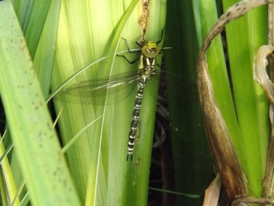
Newly emerged dragonfly (Southern Hawker) from the garden pond at Rugmoor.

is all about excursions in the countryside including caving and digging trips, walks and thoughts.
Simmonds, V. 2014. An overview of the archaeology of Mendip caves and karst. Mendip Cave Register & Archive (MCRA). (currently being revised, 2016)
An overview of the archaeology of Mendip caves and karst is freely available online at www.mendipgeoarch.net and in the archaeology section of the Mendip Cave Register & Archive at www.mcra.org.uk
Newly emerged dragonfly (Southern Hawker) from the garden pond at Rugmoor.

Hawkmoth sunning in the garden at Rugmoor on Saturday 21st June.

NGR ST 55950/55797. Field collapse near Harptree Combe c. 1.5m diameter and c. 1.25m maximum depth. Noted 05/05/2014 and still open 15/06/2014. Presently covered by old farm machinery. No rock visible only earth.

NGR ST 5386/5256. Collapse c. 2m diameter and c.1.5m maximum depth within outer ditch of Priddy Circle [No 1]. Noted on 16/04/2014.

Excavated an interesting ditch with associated post holes [15 in number] down in Dorset. Unfortunately no dating evidence was recovered just one piece of burnt flint.
Walked up through Harptree Combe to take a look at Garrowpipe Spring on a pleasant Sunday morning – dry, bit of a breeze and good visibility. There was a good flow of water in the previously noted collapse. The more I look at this site, the more I think “what an interesting little digging project this would be”. The site has been dug in the past by the Bristol Exploration Club in 1972. Barrington and Stanton (1977) record a mean daily flow of 40 000 gallons with no proved feeders.

2nd January 2014.
Bronze Age barrow with ditch, one of a small group of barrows, located in Stockhill Woods, Priddy, Mendip. As with many of the barrow’s found on Mendip it has been subjected to the attentions of the Rev. Skinner in the 19th century.
Took a walk with the dog over to Rowberrow Cavern NGR ST 4596 5802. A large archway in Dolomitic Conglomerate, closes down with a small side passage to the left, there is evidence of limited digging in a couple of other places. Archaeological excavations by the UBSS in the 1920,s revealed Neolithic, Bronze Age , early Iron Age and Romano-British habitation.

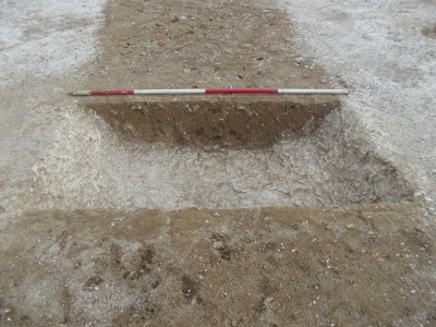
Natural solution features in Downside Stone exposed during an archaeological evaluation. Downside Stone is a littoral (near-shore) variation of the Langport Member and Blue Lias Formation. It is described as a typically white, coarsely crystalline, shelly and sandy limestone. Scale is 0.50 metres.

A swallet/sinkhole [ST 5393 5249] exposed during an archaeological investigation at the Priddy Circles, Mendip Hills. The rock is grey weathered/water worn shelly limestone, scale is 1 metre. Now backfilled.
I haven’t done a lot of digging on the chalk, so enjoyed the
opportunity when it arose.
Trench No. 5:
This linear ditch with E<->W alignment, bottomed out
at 1.35m and was cut into the natural [weathered] chalk. It had steeply sloping
sides to a narrow, flat base and became a bit constricted about halfway down. Scale is 2 metres long although the top is slightly cut off, poor light for photo’s.

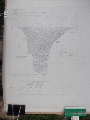
This is my 1:10 section drawing of the above ditch cut,
below the section drawing is the start of the 1:50 plan of the evaluation trench.
This was before the job was postponed at short notice due to
a pair of Stone Curlew’s deciding to nest very close to the site indeed!

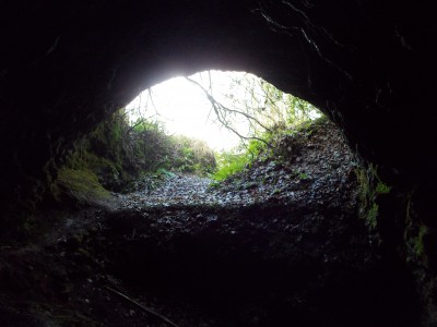
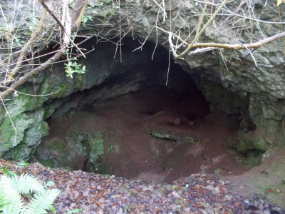
23rd June 2013. Ramspit [Scrambles Swallet], Ebbor. NGR ST 5152 4913
Small stream that rises on Coal Measures sinks into the limestone at the Ebbor Thrust, in a cliff-girt depression under the left bank, and follows a steeply descending passage choked with clay, gravel and boulders. Dug by the MNRC in 1930-32, and the BEC in 1957, the hole was closed by 1968 (Barrington and Stanton, 1977).
Not completely filled in, it would only take a little bit of gardening to open it up and make it workable, I thought that I could detect a faint draught. The right hand (west) wall appears to comprise a mineral vein [probably calcite], a vein is also visible at the current limit of the cave. Geologically an interesting little spot in that the cave follows the thrust.
